| Dist. |
Location |
Elevation |
Marking |
Description |
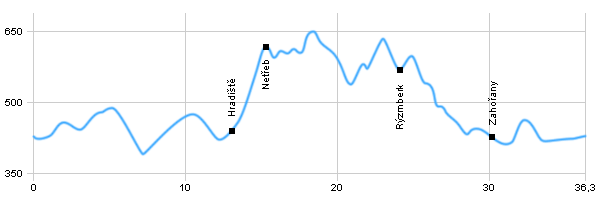
| 0,0 |
Domažlice |
425 m n.m. |
 |
|
| 3,0 |
Chrastavice |
446 m n.m. |
 |
 |
| 7,0 |
Milavče |
397 m n.m. |
 |
 |
| 12,8 |
Hradiště |
423 m n.m. |
 |
|
| 15,2 |
Ruins Netřeb |
603 m n.m. |
   |
 crossroad crossroad |
| 15,7 |
Netřeb crossroad |
638 m n.m. |
 |
|
| 23,3 |
Podzámčí |
596 m n.m. |
 |
crossroad |
| 24,1 |
Ruins Rýzmberk |
592 m n.m. |
 |
green tourist route |
| 30,2 |
Zahořany |
416 m n.m. |
 |
 |
| 32,7 |
Bořice |
457 m n.m. |
 |
|
| 36,3 |
Domažlice |
425 m n.m. |
|
|
 | Chrastavice - between the Chrastavice and Milavče there is a mohyle cemetery. One of the most prominent mohyle of Europe's prehistoric origin, is located about 500 m east of the low-lying trail. |  | Milavče - the most important historical sights in Milavče are the Church of St Adalbert and the Chapel of Adalbert. |  | Ruins of Netreb – the ruins of the medieval castle. The ruins are open year round. |  | Ruins of Rýzmberk - ruins of castle from the second half of the 13th century. View tower built in 1847, opened only in the opening hours. |
|


